Master Plan Recommendations
Native Ecology and Water Quality
Current Condition
The stunning natural context provides an outdoor playground that is the envy of many. A mere stone’s throw away, Chatfield Reservoir, Waterton Canyon, Roxborough State Park and the Dakota Hogback Open Space offer unprecedented natural open space and recreational opportunities. More proximate, the open space areas, trail network, playgrounds and community amenities within the District offer other opportunities to enjoy the beautiful Colorado outdoor lifestyle.
The ecology and environmental areas that make up the open space system include three major categories: 1) the Dakota Hogback, 2) Little Willow Creek drainage, and 3) ponds, creek, and wetlands, which create a diverse environment and habitat for the various species that inhabit the area. From the riparian areas to the upland zones and dramatic Hogback, residents and wildlife enjoy a rich array of habitat zones and landscape experiences.
Major Landscape Categories
Dakota Hogback
The dramatic and rugged terrain of the Hogback area is an unique amenity and hiking area for residents of RVMD. The vegetative cover varies from forested areas with ponderosa pine to shrublands with Gambel oak that transitions to grasslands on the lower edges where residents can access the trailheads. The overall ecologic health of the Hogback ridge is in good condition due to the ongoing efforts to conserve and protect the area as a designated open space with limited use by residents. Areas to the south between Roxborough Park and RVMD provide a healthy ecological corridor with sustained plant and tree growth, while areas north near the mining operations to the west of RVMD become more fragmented and somewhat bare.
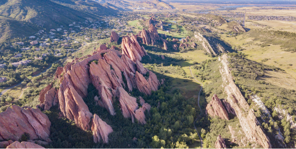
Aerial photography of the Dakota Hogback
Recommendations and Maintenance Needs
- Continue to promote the conservation, protection, and preservation of the natural terrain and plants.
- Provide signage, trail maps and markings to signify trails and notify hikers to stay on the designated paths and protect the native landscape.
- Provide new designated access points and trails where residents have created social paths or shortcuts.
- Partner with Roxborough Park and others to create educational material and signage that informs users of the sensitive landscape, special geology, and habitat areas.
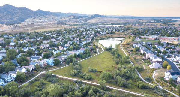
Little Willow Creek
Little Willow Creek originates near Roxborough State Park flows through the District, and into the High Line Canal. The riparian habitat corridor includes willow and broadleaf cattail, and grasses and understory shrubs. Large trees form the overstory, which includes peachleaf willow and plains cottonwood. The creek and corridor provide habitat for small mammals, songbirds, and waterfowl. Regular use by deer, small rodents, coyote, fox, skunk, beaver and raccoon indicates that opens space is a healthy ecological corridor that connects to the larger network and supports a healthy animal community. The Preble’s meadow jumping mouse, which is common to Little Willow Creek, is discussed in the latter part of this section.
Little Willow Creek Drainage
Recommendations and Maintenance Needs
- Enhance and naturalize the landscape and improve native habitat along the creek by bringing on an ecologist to conduct an annual evaluation. Develop a set of recommendations for the creek corridor.
- Conduct a corridor study to prevent creek degradation and erosion along its edges. Evaluate potential creek improvements, including adding check dams, weirs, and other devices to mitigate erosion during major storm events.
Ponds and Water Quality
7-Acre Pond at Arrowhead Shores | Crystal Lake
Crystal Lake at Arrowhead Shores functions as a primary storage area for irrigation and the main aesthetic amenity for the community. Although the District does not own the lake, it is the District’s responsibility to maintain the facility under an easement agreement with Arrowhead Shores HOA, and it has overseen annual improvements related to water quality and stabilization along the lake’s edges. While these incremental improvements have helped sustain the water quality and the edges of the lake, a longer-term strategy to improve the overall health and natural qualities of the lake edges could reduce annual maintenance costs.
While the overall aesthetic of the lake is pleasing, its engineered shape, edges, and function related to water storage for irrigation creates inherent challenges to establish a natural condition for good water quality, and to reduce erosion along the lake’s edges. The District addressed water quality and erosion through additional engineered solutions, such as the installation of aerators and large boulders along the lake edge to mitigate erosion. Although these measures have worked, they often create recurring annual maintenance needs that proved to be costly over time.
Recommendations and maintenance needs:
- Continue to focus on stabilization of the shoreline but the District should evaluate the feasibility of using emergent wetland plants. Use of riprap has proven to be generally effective, but several boulders area already beginning to move which exposes areas for continued erosion.
- Study improving the slope of the bank, so that slopes are no more than 3 to 1 (3 feet of width for every foot in height). This may be challenging due to the water volume requirement in the pond. However, the District can work with the HOA to determine if there are locations where the pathway can be shifted to allow room for more gentle slopes.
Little Willow Creek Upper Pond and Lower Pond | Heron and Tadpole Ponds
Heron and Tadpole Ponds are located on the northern section of Little Willow Creek, and provide a two-tier pond system originally engineered for detention purposes. The engineered shapes and elevated walkway/spillway between the two ponds reflect their functions as devices to detain and control the release of water before it travels offsite to areas north of the District. Although the two ponds have historically required minimal maintenance, the facilities need improvements to enhance the water quality, remove sediment, and repair the riprap and spillway structure between the two ponds. The need for future improvements provides an opportunity for the District to enhance the ponds so they can offer improved amenities that function better hydraulically and ecologically.
Recommendations and maintenance needs:
- Remove and replace the existing sidewalk and repair/replace the riprap on the earthen barrier between the two ponds.
- Dredge the ponds to remove sediment that has built up over time and create varying areas of depth so that the ponds create healthy aquatic habitat.
- Reshape the edges of the Heron Pond as a part of the dredging process to create more natural edge condition that works with the hydrologic flows moving through the pond.
- Enhance the native species around the ponds, including trees, shrubs, grasses, and other herbaceous vegetation. The native aquatic vegetation will enhance the ecological habitat.
Community Park Pond | Preble’s Pond
Preble’s Pond provides a water amenity near the Community Park and is a popular place for fishing. With naturalized edges and wetland plantings, the pond is visually the most natural-looking of all the ponds in the community. Located at a lower area near Little Willow Creek, residents enjoy the pond as they walk along the multi-use trails, spend time in the park or when using the recreational fields and courts. Today, the pond is naturally filled by rainwater and drainage along the corridor.
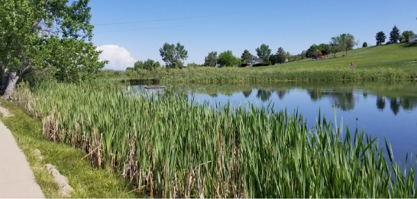
Preble’s Pond provides habitat to Preble’s meadow jumping mouse
Recommendations and maintenance needs:
- Continue to maintain and enhance the aquatic and wetland habitat along the pond’s edges
- Provide controlled access points, docks or boardwalks to protect plants and edges of the pond from erosion and damage from residents fishing.
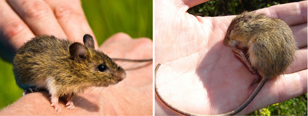
Preble’s meadow jumping mouse
Preble’s meadow jumping mouse (Preble’s) is listed as a threatened species under the federal Endangered Species Act by the U.S. Fish and Wildlife Service (the Service). Preble’s lives primarily in thick vegetation along stream corridors, adjacent uplands, and ditches in the Front Range of Colorado. Its diet consists of insects, seeds, fungus, fruit and more. Due to the climate becoming drier in the Front Range of Colorado and foothills of Wyoming, Preble’s habitat shrank and were confined to riparian systems where moisture is abundant.
In Colorado, Preble’s are distributed throughout Adams, Arapahoe, Boulder, Denver, Douglas, El Paso, Elbert, Jefferson, Larimer, and Weld counties. Rapid growth and development in Colorado have impacted the Preble’s habitat.
Recommendations
Little Willow Creek is identified as a habitat corridor for Preble’s meadow jumping mouse. Preble’s habitat zone is protected under the Riparian Conservation Zone defined by Douglas County. (Shown in map).
If the District continues current maintenance practice, no action is needed.
If the District decides to make any temporary or permanent changes to the land within the Preble’s habitat’s zone, such as dredging, filling in streams or wetland, new construction, significant changes to surface landscaping, or increased usage by humans or domestic animals, a permit is required from the Service. To obtain a permit, the District will need to develop a Habitat Conservation Plan that outlines actions to minimize and mitigate disturbances to the Preble’s habitat during proposed activities. Consult the Service to learn more about permit application process.
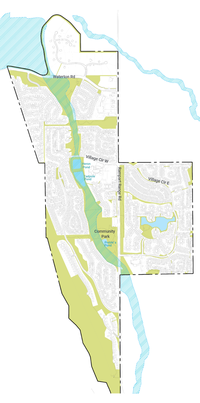
Riparian Conservation Zone Map
Area shaded in blue indicates Riparian Conservation Zone. Any future development that will disturb the Riparian Conservation Zone will require a permit from U.S. Fish and Wildlife Service, and must develop a Habitat Conservation Plan to mitigate the impact.